
Los Angeles County
Drone services in Santa Clarita
Master-planned residential development, large graded pads, and film production ranches. Some of the busiest earthwork mapping in the county.
FAA Part 107
Certified remote pilot in command
Documented flights
Authorized, logged, and repeatable
Airspace cleared
Approval to fly your site is on us
Operating since 2023
Same pilot on every flight
Airspace
Flying legally in Santa Clarita
Mostly open airspace, with approval needed near the Whiteman and Van Nuys approach paths.
Every flight in Santa Clarita is flown under Part 107, with FAA approval filed wherever the location requires it, property owner notification where the site calls for it, and a logged record of the operation. Where a site sits close enough to an airport that approval takes longer, we tell you up front and start that clock rather than discovering it on the shoot day.
Areas we work most
- Valencia
- Newhall
- Castaic
Industries in this area
Services
What we fly in Santa Clarita
 DW-01
DW-01Aerial Photography & Video
20 MP stills and 4K video, edited and delivered
 DW-02
DW-02Orthomosaic Mapping & Site Surveys
RTK-corrected orthomosaics built for CAD and GIS
 DW-03
DW-033D Modeling & Photogrammetry
Textured meshes and photogrammetric point clouds
 DW-04
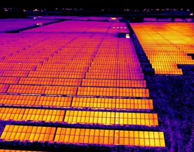
DW-04Thermal Imaging & Inspection
Radiometric surveys for roofs, solar, and infrastructure

FPV Cinematography
One-take flythroughs and high-speed pursuit
Get started
Book a flight in Santa Clarita
Send the address and the deliverable. Quotes go back by the next business day.
Tell us what you need documented
Send the address, the deliverable, and your target date. Most quotes go back by the next business day.