
Los Angeles & Kern Counties
Drone services in Antelope Valley
Utility-scale solar, open land, and long-range mapping. Wide-area capture where flight planning and battery logistics decide the day.
FAA Part 107
Certified remote pilot in command
Documented flights
Authorized, logged, and repeatable
Airspace cleared
Approval to fly your site is on us
Operating since 2023
Same pilot on every flight
Airspace
Flying legally in Antelope Valley
Restricted and military areas require coordination up front; the valley floor itself is largely open.
Every flight in Antelope Valley is flown under Part 107, with FAA approval filed wherever the location requires it, property owner notification where the site calls for it, and a logged record of the operation. Where a site sits close enough to an airport that approval takes longer, we tell you up front and start that clock rather than discovering it on the shoot day.
Areas we work most
- Palmdale
- Lancaster
- Mojave
Industries in this area
Services
What we fly in Antelope Valley
 DW-01
DW-01Aerial Photography & Video
20 MP stills and 4K video, edited and delivered
 DW-02
DW-02Orthomosaic Mapping & Site Surveys
RTK-corrected orthomosaics built for CAD and GIS
 DW-03
DW-033D Modeling & Photogrammetry
Textured meshes and photogrammetric point clouds
 DW-04
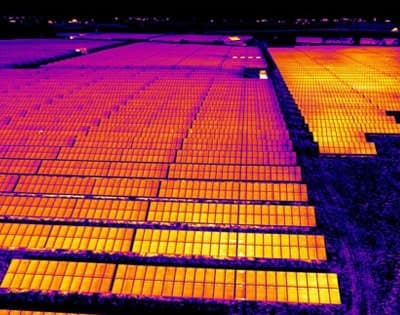
DW-04Thermal Imaging & Inspection
Radiometric surveys for roofs, solar, and infrastructure

FPV Cinematography
One-take flythroughs and high-speed pursuit
Get started
Book a flight in Antelope Valley
Send the address and the deliverable. Quotes go back by the next business day.
Tell us what you need documented
Send the address, the deliverable, and your target date. Most quotes go back by the next business day.