
Commercial drone services for Los Angeles and Southern California
Aerial photography, RTK site mapping, 3D models, and radiometric thermal inspection — scoped to the deliverable your project actually needs and delivered in days, not weeks.
- 48 hr
- Media delivery
- 2023
- Operating since
- 120 mi
- Service radius

Sample deliverable
Site orthomosaic
- CaptureRTK double grid
- Coverage80 ac/day
- FormatGeoTIFF
FAA Part 107
Certified remote pilot in command
Documented flights
Authorized, logged, and repeatable
Airspace cleared
Approval to fly your site is on us
Operating since 2023
Same pilot on every flight
Capabilities
What we fly
Aerial photography and video, orthomosaic mapping, 3D modeling, thermal inspection, and FPV cinematography. All flown and processed in house.
 DW-01
DW-01Aerial Photography & Video
20 MP stills and 4K video, edited and delivered
DW-02Orthomosaic Mapping & Site Surveys
RTK-corrected orthomosaics built for CAD and GIS
 DW-03
DW-033D Modeling & Photogrammetry
Textured meshes and photogrammetric point clouds
 DW-04
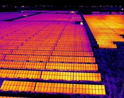
DW-04Thermal Imaging & Inspection
Radiometric surveys for roofs, solar, and infrastructure
 DW-05
DW-05FPV Cinematography
One-take flythroughs and high-speed pursuit
Who we work with
Industries
A listing photo and a stockpile volume report are not the same job. Each industry is scoped, flown, and priced differently.

Real Estate
Listing media that moves properties faster
Aerial stills and video that show lot lines, proximity, and scale in a way ground photography cannot.

Construction
Documented progress your owner and your subs both trust
Repeatable flight plans flown from the same waypoints every visit, so month three lines up with month one.
Inspection
Radiometric data, not just pretty pictures
Roof moisture surveys, PV array fault-finding, and infrastructure condition assessment flown with calibrated radiometric sensors.

Film & Brand
Cinema-grade aerials and FPV that cut into your timeline
20 MP stills, 4K plates, and high-speed FPV shot in 10-bit log so your colorist has room to work.
How it works
A process built around the deliverable
The flight is the easy part. What makes a project succeed is the scoping before it and the processing after it.
01
Scope the deliverable
We start from what the output has to do, not from what a drone can do. That decides the sensor, the flight plan, and the price.
02
Clear the airspace
Airspace approval and property owner notification are handled before the crew leaves, not on the morning of the flight.
03
Fly the plan
Repeatable, logged flights. On recurring sites we fly the same waypoints every visit so the data actually compares.
04
Process and deliver
Edited media in 48 hours. Mapping, models, and thermal reports in 3 to 7 business days, with the source data included.

Why Drone Works
Why clients book us
Law enforcement flight background
Founded by a pilot who spent a career in law enforcement, where flights are planned, authorized, and logged before they happen. Commercial jobs are run the same way.
You get the source data, not a screenshot
Radiometric files, georeferenced GeoTIFFs, photogrammetric point clouds, and RAW stills. Whatever your engineer, colorist, or GIS analyst needs to verify the work themselves.
Scoped so the price is knowable up front
Published starting prices on every service, a fixed travel radius, and no surprise line items for the authorization work that should have been included.
Common questions
What clients ask before booking
Are you licensed to fly commercially?
Yes. Every flight is conducted by an FAA Part 107 certified remote pilot in command, under the airspace authorization the site requires, and logged with aircraft, pilot, and conditions. Documentation your project or property owner needs is provided on request.
Can you fly in controlled airspace around LAX or Burbank?
Yes. Most controlled airspace in the LA basin is covered by LAANC and authorization comes back in minutes to hours. Locations inside the tightest airport surfaces need a Part 107 airspace waiver, which takes about 90 days, so tell us early if that is your site.
How fast do I get my files?
Photo and video shoots deliver in 48 hours. FPV rushes go out in 72 hours. Mapping, 3D models, and thermal reports run 3 to 7 business days depending on site size. Rush delivery is available on most jobs.
How far do you travel?
We work a 120-mile radius from the LA metro, which covers Los Angeles, Orange, Ventura, San Bernardino, Riverside, and southern Kern counties. Travel inside 60 miles is included in the quoted price.
What happens if the weather cancels my shoot?
We reschedule at no charge. We will not fly a job in conditions that put the aircraft, the site, or the deliverable at risk, and you are never billed for a flight we chose not to make.
Do I own the footage?
You receive a perpetual, unlimited license to use the deliverables for your business. We retain the right to show the work in our own portfolio unless the project is under NDA, which we are glad to sign.
Tell us what you need documented
Send the address, the deliverable, and your target date. Most quotes go back by the next business day.